Geography
Perhaps the worst geography nightmares for genealogists have occurred in the area near the head of the Ohio River. This land has belonged to western Pennsylvania, western Virginia, West Virginia and eastern Ohio counties (particularly what is currently the West Virginia panhandle). To make matters worse, folks would often switch from one state or county to another because it was easier to find a parson, a judge, etc. so your records could be anywhere!
Of course, Pennsylvania and Virginia are two of the original 13 colonies. There is an interesting treatise on the colonial boundaries found on the Wheeling Area Genealogical Society site, which has an extensive history of the upper Ohio River valley. Ohio was admitted to the Union in 1803. West Virginia was granted statehood in 1863. The Perry-Castañeda Library Map Collection, at the University of Texas, Austin, has extensive holdings, including the Census maps of the US. Perhaps the most interesting is the one of all the Territorial acquisitions superimposed on the modern states borders.
“For several years prior to 1773, the area defining the western boundary of Pennsylvania and current day West Virginia had been in dispute between the colonies of Pennsylvania and Virginia. This dispute was compounded by the issuance of land grants by the respective colonies for the same lands. In 1773, the Pennsylvania legislature created Westmoreland County which included all lands in dispute with Virginia, inclusive of West Augusta, Virginia.
The West Augusta district boundaries as defined by an Act of the Virginia general assembly in 1776 included the present day northern panhandle of West Virginia, Greene and Washington Counties in Pennsylvania, and portions of Allegheny and Beaver counties in Pennsylvania. This act created three counties Ohio, Monongahela, and Yohogania. On August 31, 1779, agreement was finally reached between Virginia and Pennsylvania establishing a boundary based on the survey of Mason and Dixon. This agreement was ratified June 23, 1780 by the Virginia general assembly and September 22, 1780 by Pennsylvania’s general assembly. If this act had been fulfilled in its entirety, the northern panhandle of West Virginia would have been a part of Pennsylvania rather than Virginia.
Upon ratification Ohio County consisted of present day Hancock, Brooke, Ohio, Marshall, Wetzel, Tyler, Doddridge, and Pleasants counties.
1796 – Brooke County created, encompassing present day Brooke and Hancock counties
1814 – Tyler County created, emcompassing all or parts of present day Tyler, Wetzel, Doddridge and Pleasantscounties
1835 – Marshall County created
The site of present day West Liberty was selected to be the site for the county courts in Ohio County. West Liberty was organized November 20, 1787 and was the first town organized in the Ohio Valley. The county courts were subsequently moved to Wheeling May 7, 1798.” [1]
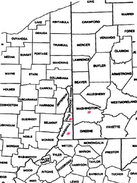
I have excerpted the sections of the maps that pertain to my geographic area as noted below and marked the key counties. [2] This area is home to the Bushfields, Erskines and McFarlands. The Dobles were in Bucks Co, PA (east of Philadelphia) and went directly to Indiana. Ohio and Marshall Counties VA/WV were once one, under the name of Ohio.
 Modern map of the area
[1] from the West Virginia US GenWeb site’s history page
[2] US Department of Commerce, Economics and Statistics Division, Bureau of the Census, 1990.
Back to Genealogy Home
Contents Copyright © 2000, 2022 Christine A. Doyle